


The Channel Islands
Discover the beauty of The Channel Islands that lie off the coast of California. Learn more about all eight of the Channel Islands by scrolling down.
The Channel Islands
Discover the beauty of The Channel Islands that lie off the coast of California. Learn more about all eight of the Channel Islands by scrolling down.
The California Channel Islands lie off the California coast between Point Conception and the Mexican border. Public visitation is allowed on six of the eight islands. These include the islands of Channel Islands National Park, located primarily near Santa Barbara and Ventura. Much of Santa Catalina Island, near Long Beach, is also open to public visitation. All six islands that are open to the public offer campgrounds, miles of hiking trails, kayaking, swimming, snorkeling, diving, whale watching, plus spectacular views. Catalina offers all of these, plus entertainment that also available in a modern tourist destination.
Most people begin their discovery of the islands and the surrounding ocean by taking a day trip to the closest islands (Anacapa, Santa Cruz and Catalina) or by whale watching near the islands. A day trip offers spectacular views of the ocean and a very good opportunity to see dolphins, whales and other wildlife. Whale watching trips focus and the marine life, and usually do not include an opportunity to land on an island. Day trips that land on an island offer the opportunity to hike on trails and explore visitor centers (Anacapa and Santa Cruz Island) or to visit the city of Avalon or Twin Harbors on Catalina Island.
Overnight trips offer visitors the opportunity to see more remote parts of the islands that are not accessible to day trippers. The only island that offers amenities like hotels and restaurants is Catalina (which also has campgrounds). Otherwise, you stay in campgrounds, bring your own food, and in some cases, your own water. San Nicolas and San Clemente Islands are owned by the U.S. Navy, and the public is prohibited from landing there, although some charter companies offer diving trips near those islands.
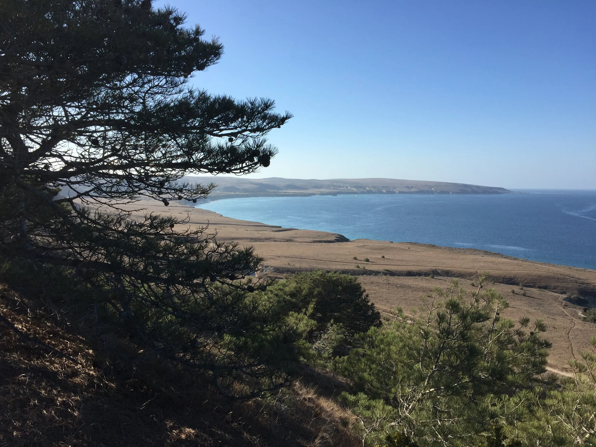
Santa Cruz Island
Santa Cruz Island
At 96 square miles, Santa Cruz Island (Chumash: Limuw, meaning 'in the sea') is the largest of the eight Channel Islands. About one-quarter of this island is owned by Channel Islands National Park (the eastern end) and the rest is owned by the Nature Conservancy. The National Park side of the island offers the recreational opportunities, and the Nature Conservancy part is mostly closed to the public, with some exceptions. Boat owners can land on some of the Nature Conservancy property with a Conservancy permit, and the public is allowed to hike on the Pelican Trail (starting at Prisoners’ Harbor) with a guide from Island Packers.
Anacapa Island
Anacapa Island
Anacapa Island (Chumash: Anyapakh, meaning 'mirage') is just 12 miles from the mainland, and at only 1.1 square miles in size, it is the second from the smallest of the eight Channel Islands.
The island, which is wholly owned by Channel Islands National Park, consists of three land masses called “islets” that are named “East,” “Middle,” and “West” Anacapa Island respectively. Only East Anacapa and one spot on West Anacapa (Frenchy’s Cove) are open to the public.
A visit to East Anacapa is an ideal way to get a “taste” of visiting the islands with kayaking excursions and/or hikes on short and easy trails. The sights include spring wildflowers, breeding gulls in the summer, a small visitor’s center, plus historic 1930s era buildings, including a lighthouse.
“Inspiration Point” on the western end of East Anacapa, provides a spectacular view of Middle and West Anacapa Island, plus the eastern end of Santa Cruz Island. The 30 sea caves and marine wildlife make for excellent kayaking adventures.
Santa Rosa Island
Santa Rosa Island
Santa Rosa Island or Wi'ma as the Chumash called it (meaning driftwood) is the second largest of the eight Channel Islands. At 84 square miles, Santa Rosa Island is the second largest of the eight Channel Islands. In addition to being large, Santa Rosa is rather remote and windswept, but full of rugged beauty and unique features. It is owned wholly by Channel Islands National Park. It is more than 30 miles from Santa Barbara and around 40 miles from the Ventura Harbor.
Santa Rosa offers many miles of hiking trails and sandy beaches, spectacular views, an amazing grove of Torey Pine trees, historic buildings and Lobo Canyon, which is one of the most amazing hikes on the Channel Islands. Depending on the weather, Island Packers usually visits Painted Cave on Santa Cruz Island on the return trip to Ventura.
Visiting Santa Rosa is not for the faint of heart. Much of the time the island is swept by howling winds, and visitors need to walk long distances to the campground and to some of the more interesting trailheads. After you have experienced the relatively more placid environment of East Santa Cruz or Anacapa, Santa Rosa may present you with a bigger challenge, but you will also experience many rewards in beauty and adventure. This is also one of only two islands in Channel Islands National Park that the public can reach by plane. Island Packers offers trips from April to early November.
San Miguel Island
San Miguel Island
At 14 square miles, San Miguel (Chumash: Tuqan, translation unknown) is the third smallest of the eight Channel Islands. It is owned by the U.S. Navy, but the island is administered by Channel Islands National Park. Windswept, beautiful and remote, San Miguel is for the hearty visitor and is a sanctuary for breeding pinnipeds and seabirds. Cuyler Harbor on the island’s northern shore is lined with dunes and native vegetation and a large rock called “Prince Island” is just off shore. On a clear day, the views from Harris Point and Point Bennett are truly amazing, with the later covered in tens of thousands of pinnipeds.
Like with Santa Rosa, visiting San Miguel is not for the faint hearted. Much of the time the island is swept by howling winds, and visitors need to walk long distances to the campground and to some of the more interesting trailheads.
After you have experienced the more relatively placid environment of East Santa Cruz or Anacapa (or even Santa Rosa) San Miguel may present you with a bigger challenge, but you will also experience many rewards in beauty and adventure. This is also one of only two islands in Channel Islands National Park that the public can reach by plane.
Santa Barbara Island
Santa Barbara Island
At one square mile, San Barbara is the smallest of the eight Channel Islands, and it is wholly owned by Channel Islands National Park. Known for its remoteness and water sports opportunities, Santa Barbara Island is also a sanctuary for seabirds and pinnipeds.
The small size of the island and its remote location (55 miles from Ventura, 38 miles from the mainland and 24 miles from the west end of Catalina Island) really gives the visitor the feeling of being on an island. The clear waters and ample marine life make Santa Barbara Island a wonderful place to dive, snorkel and swim.
Santa Catalina Island
Santa Catalina Island
At 75 square miles, Santa Catalina (most often referred to simply as “Catalina”) is the third largest of the eight California Channel Islands. Catalina is the most visited of the islands, due to its early history of tourist development and its proximity to Los Angeles. Although known chiefly for the City of Avalon, where people visit for the day and stay overnight in hotels, Catalina also offers lots of hiking and camping opportunities, along with many water sport options.
San Nicolas Island
San Nicolas Island
San Nicolas Island is the most remote of California's Channel Islands, located 61 miles from the nearest point on the mainland coast. It is part of Ventura County. The 14,562 acre (22.753 sq mi) island is controlled by the United States Navy and is used as a weapons testing and training facility, served by Naval Outlying Field San Nicolas Island.
San Clemente Island
San Clemente Island
San Clemente Island is the southernmost of the Channel Islands of California. It is owned and operated by the United States Navy, and is a part of Los Angeles County. it is roughly 21 miles long and contains 57 sq mi of land.