


Santa Rosa Island
Santa Rosa Island
About Santa Rosa Island
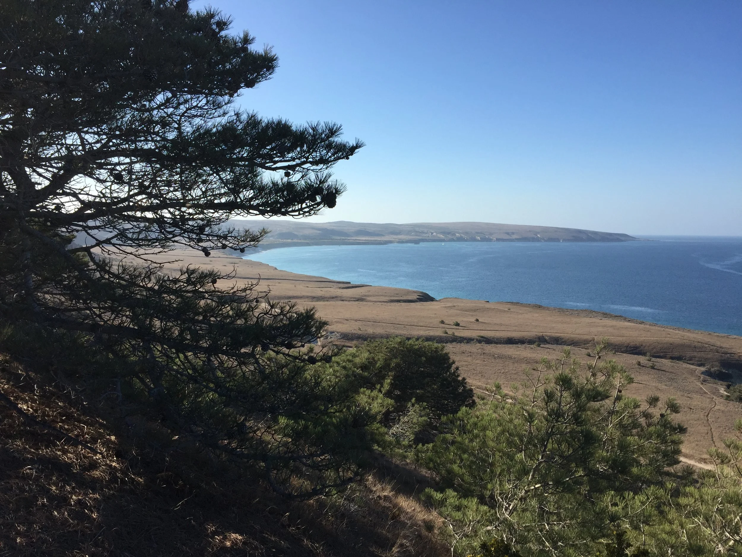
Santa Rosa Island or *Wi'ma* as the Chumash call it (meaning driftwood) is the second largest of the eight Channel Islands. In addition to being large, Santa Rosa is rather remote and windswept, but full of rugged beauty and unique features. It is owned wholly by Channel Islands National Park. It is more than 30 miles from Santa Barbara and around 40 miles from the Ventura Harbor.
Santa Rosa offers many miles of hiking trails and sandy beaches, spectacular views, an amazing grove of Torey Pine trees, historic buildings and Lobo Canyon, which is one of the most amazing hikes on the Channel Islands. Depending on the weather, Island Packers usually visit Painted Cave on Santa Cruz Island on the return trip to Ventura.
Visiting Santa Rosa is not for the faint of heart. Much of the time the island is swept by howling winds, and visitors need to walk long distances to the campground and to some of the more interesting trailheads. After you have experienced the relatively more placid environment of East Santa Cruz or Anacapa, Santa Rosa may present you with a bigger challenge, but you will also experience many rewards in terms of beauty and adventure. This is also one of only two islands in Channel Islands National Park that the public can reach by plane. Island Packers offers trips from April to early November.

Looking out over Santa Rosa Island
Invasive Plant Surveys
In 2006 Channel Islands Restoration worked for the Santa Barbara County Agricultural Commissioners Office to survey and eradicate noxious
invasive plants on Santa Rosa Island.
Invasive Plant Surveys
In 2006 Channel Islands Restoration worked for the Santa Barbara County Agricultural Commissioners Office to survey and eradicate noxious
invasive plants on Santa Rosa Island.
Santa Rosa Island Noxious Weed Survey and Eradication
Channel Islands Restoration staff and volunteers joined other stakeholders in mapping all known populations of Yellowspine Thistle and Silverleaf Nightshade with GPS units. They then pruned the natives surrounding the invasive plants while also removing any growing fruits from the invasives in order to prepare the sites for herbicide treatment. Once the invasive plants were killed, we planted native plants in the open areas to impede invasives from resprouting.
For the nitty gritty details, visit the County of Santa Barbara's Official Project Page and read the final report here.

Targeted Species:
Yellowspine thistle (Cirsium ochrocentrum) is designated by the California Department of Food and Agriculture as an "A" rated noxious weed. 1 Populations of this weed are of very limited distribution in California. In Santa Barbara County, it is only known to occur on Santa Rosa Island. Large infestations could ruin a landscape for rangeland, recreation, and wildlife habitat. - Santa Barbara Agricultural Commissioner.

Yellowspine thistle (Cirsium ochrocentrum)
Silverleaf nightshade (Solanum elaeagnifolium), also known as white horsenettle, is designated by the California Department of Food and Agriculture as a "B" rated noxious weed.2
Populations of this weed are of limited distribution in California. In Santa Barbara County it has been found on Santa Cruz Island from the Christy Barn area to the Christy airfield area and in Cebada Canyon, but is still very localized. It is found on Santa Rosa Island as well. These Channel Islands populations have received repeated treatments as part of the SBCWMA's Santa Rosa Island Noxious Weed Survey and Eradication Project. A population was found in 2009, and treated [by CIR], on the San Marcos Foothills. Additional historical collections have been made at the Bishop Ranch near Goleta, along a Solvang roadside, along Meigs Road in Santa Barbara, and at the mouth of Rattlesnake Canyon.

Silverleaf nightshade (Solanum elaeagnifolium)
1 "A" rated noxious weeds are plants of known economic importance subject to enforcement action and are the highest priority for eradication by the CDFA and the SBCWMA. Populations of this weed are of very limited distribution in California. In Santa Barbara County, it is only known to occur on Santa Rosa Island. Large infestations could ruin a landscape for rangeland, recreation and wildlife habitat.
2 "B" rated noxious weeds are plants of know economic importance subject to enforcement action and are a high priority for control by the CDFA and the SBCWMA.
Santa Barbara Agricultural Commissioner.
Endangered Species Conservation
Channel Islands Restoration has worked with Channel Islands National Park and several other partners, service groups and individual volunteers on many exciting projects on Santa Rosa Island.
Endangered Species Conservation
Channel Islands Restoration has worked with Channel Islands National Park and several other partners, service groups and individual volunteers on many exciting projects on Santa Rosa Island.
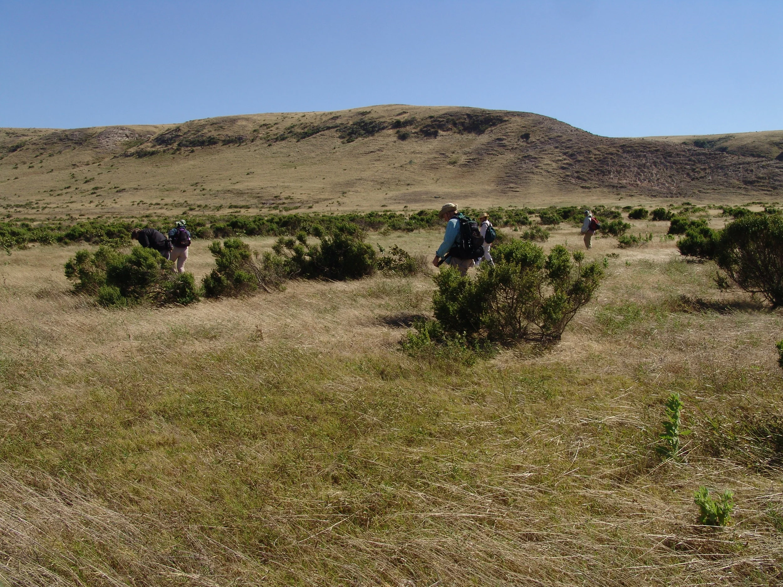
Species Conservation On Santa Rosa
Channel Islands Restoration has worked with Channel Islands National Park and several other partners, service groups and individual volunteers on many exciting projects on Santa Rosa Island. We have planted native species, helped grow native plants in the island nursery, protected rare plants by erecting and then removing fencing, surveyed for and eradicated noxious weeds and controlled weeds in many places on the island including on miles of island roads.
Volunteers make multi-day trips to the island to work with us on these projects, which are perfect for individuals and corporate and service groups.
Channel Islands Restoration assisted park biologists with their work to conserve the endangered and endemic Phacelia insularis var. insularis.
We raked large areas of dead nonnative grass detritus in an effort to increase fertilization and germination of the Phacelia. The experimental section had a slightly higher success rate when compared to a control, but it wasn't substanial.
We also propagated and planted a species of extremely rare and endemic Dudleya at China Camp on the southwest side of the island.

East Point Ice Plant
Ice plant (specifically Carpobrotus edulis) is such a ubiquitous
invasive plant on the mainland that eradication seems almost futile.
East Point Ice Plant
Ice plant (specifically Carpobrotus edulis) is such a ubiquitous
invasive plant on the mainland that eradication seems almost futile.
Ice plant (specifically Carpobrotus edulis) is such a ubiquitous invasive plant on the mainland that eradication seems almost futile. The unique factor in restoring island habitat is that with dedication to eradicating resprouts and taking strong preventative measures for all traffic coming onto the island to be clean of invasive seeds, we can actually completely remove invasives from these delicate island ecosystems.
Why remove ice plant in the first place?
I'll let the California Invasive Plant Council answer that:
"Highway iceplant tolerates a range of soil moisture and nutrient conditions and can establish and grow in the presence of competitors and herbivores. These qualities and others have meant that in many natural areas it has formed nearly impenetrable mats that dominate resources, including space. It has invaded foredune, dune scrub, coastal bluff scrub, coastal prairie, and maritime chaparral communities, and competes directly with several threatened or endangered plant species for nutrients, water, light, and space (State Resources Agency 1990).
It can suppress the growth of both native seedlings (D'Antonio 1993) and mature native shrubs (D'Antonio and Mahall 1991). In addition, it can lower soil pH in loamy sand (D'Antonio 1990a) and change the root system morphology of at least two native shrub species (D'Antonio and Mahall 1991)." - Cal-IPC

Ice Plant Removal On Santa Rosa Island
Native Plant Protection
CIR stepped in to install fencing around important plant populations.
Native Plant Protection
CIR stepped in to install fencing around important plant populations.
During the ranching era deer and elk were introduced to the island for sport hunting.
These non-native herbivores easily grazed upon the endemic island plants which had not adapted to withstand grazing.
As management of the island was nearly finished transferring from the ranchers to the National Park Service, CIR stepped in to install fencing and cages around important plant populations and around newly planted natives around our restoration sites. When deer and elk were completely removed from the island we underwent the arduous task of removing all of our now-obsolete fencing.
CIR volunteers install fencing around wetland habitat near the top of Lobo Canyon.
The Cloud Forest OF Santa Rosa Island
The project goals are to slow erosion on the island and replace the lost
fog-water harvesting vegetation, such as the rare island oak trees.
The Cloud Forest OF Santa Rosa Island
The project goals are to slow erosion on the island and replace the lost
fog-water harvesting vegetation, such as the rare island oak trees.
Restoration Above The Clouds
The project goals are to slow erosion on the island and replace the lost fog-water harvesting vegetation, such as the rare island oak trees. During the volunteer trips, erosion control devises were built and installed in areas on the island that have been severely impacted by the overgrazing of non-native species.
Volunteers sorted, loaded and transported multiple stake bed truckloads of wood to the restoration sites that were used in the construction of check dams and silt fences in eroded gullies. Volunteers pounded in rebar and posts as structural support for the dams and material silt fences.
Organic-fiber wattles and rock bags were filled and assembled, transported, and installed on the island’s ridges and around groves.
Staff and volunteers put in long but satisfying hours, knowing they were assisting in a unique and vital restoration project, and enjoying the spectacular island setting and work group camaraderie.
For more information, you can read an anecdote from our work below or visit Channel Islands National Park that has a great page on this topic.

Volunteers Working on Santa Rosa Island

Seeding The Clouds On Santa Rosa Island: A Project Anecdote By Bryan Snyder
By mid-afternoon on Santa Rosa Island, 50mph gusts tore through our work site in the cloud forest, throwing grit in our eyes faster than our tear ducts could remove it. Still, we labored to the best of our ability, working to retrofit a series of erosion control barriers beneath the island oaks before the sun set behind San Miguel Island to the west.
I’d been expecting this. The winds that fly above the Pacific waves and course through California’s Channel Islands can be intense, especially at upper elevations. As our project was situated fifty feet below the highest point on Santa Rosa, a little turbulence was unsurprising. Still, I was relieved as anyone when the call was made to retreat to the vehicles and return to staff housing. It took several minutes inside the truck before the wind-induced tension began to drain from my body. We were all a little dazed. With luck, calmer weather would reach the shores of the island by morning.

Look Out Santa Rosa Cloud Forest
Our efforts were worthy, and badly needed. [Santa Rosa Island native plant communities were negatively impacted by non-native ungulates introduced during the ranching era from about 1850s though 1990s.] The sheep chewed native plants down to the roots, and subsequent rains washed the exposed soil into the ocean. Although the worst damage had been done, cattle, elk and deer continued to degrade the landscape into the 21st century. Forests of oak and chaparral dwindled to isolated groves atop otherwise barren ridge lines. The island was purchased by the National Park Service in 1986, [and the last of the non-native ungulates were removed in 2011].
Volunteers Working on Santa Rosa Island
But there were contradictions in the recovery process. Scant rain falls upon the island, and the trees and shrubs that used to grow atop the ridge lines gleaned most of their moisture from fog, which condensed on the leaves and dripped down into the soil. Before ranching [changed] the ecosystem, this condensation produced enough groundwater to cause streams to flow at the base of the mountains. Today, there wasn’t enough vegetation to collect fog and dampen the soil. And if the soil wasn’t damp, vegetation couldn’t grow on the barren hillsides. To break the contradiction, humans had to step in and jump-start the natural processes of healing. That’s where we volunteers from Channel Island Restoration came in.
[With housing and transportation provided by NPS funding] a small group of us helped for four days to build dams across gullies to trap sediment and reduce erosion. We worked beneath the shade of the few island oak trees to survive the livestock hordes of the 19th and 20th centuries.
Vast quantities of soil had eroded away from underneath these ancient specimens, leaving them standing on stilt-like roots above crumbling bedrock. Our dams would hopefully fill with soil during rainstorms and be watered continuously by droplets of condensed fog from the oak branches overhead.
Then new plants could finally grow within the cloud forest. Until the dams filled completely with sediment, the mesh fabric lining the barriers would also serve as artificial fog collectors, pulling moisture from the clouds and helping nurture seedlings during their first years of existence.
[Channel Islands Restoration received generous funding from the National Park Service to cover the cost of equipment, supplies, housing, lodging, and staff time. Because restoration is expensive the need for volunteer assistance is critical and greatly appreciated]. By using unpaid volunteer labor along with leftover staples from past projects, t-posts from old fencing and discarded eucalyptus logs, the managers were able to get these dams built and give the cloud forest a chance to recover before the majestic trees were lost forever.
I was happy to do my part. In effect, I was helping make amends for my ancestors’ mistakes, just as my descendants will undoubtedly work to repair damage from my unwitting errors. For our efforts, we were given time to explore the east side of the island, including the grove of Torrey Pines - a subspecies found nowhere else in the world. The hillsides within the forest were carpeted with a smooth blanket of needles, which allowed the spherical pine cones to roll down the hill unchecked and collect by the thousands in depressions and gullies. Thankfully, the native mice seemed to be successful in helping the species expand its territory by planting seeds in the grasslands above the grove. Five-foot saplings dotted these adjacent slopes, which helped me feel more optimistic about the resilience of the island. Part of me wished that twenty years could flash by in a heartbeat so I might witness the results of our efforts in the cloud forest. I am often disheartened by the impact our species has had on the planet, from habitat destruction to the altering of our very climate. To maintain hope, it helps to see evidence of recovery, for it nurtures my belief that poor decisions made for short-term gain can sometimes be healed and forgiven.
Such evidence swam by our boat as we crossed the Santa Barbara Channel on our way back to the mainland - a blue whale. Whaling had reduced the population of these leviathans by over 99% during the 20th century, but now their numbers were unquestionably rising again. If the largest animal in Earth’s history could mount a comeback, then something as big as the hydrology of an entire island stood a chance of recovering as well. I chose to dwell on that thought as the beast exhaled a great burst of air and mist, then slid out of sight once again into an ocean lit by the last rays of a November sun.
For more of Bryan Snyder’s stories and photographs, visit www.offthemapbooks.com or www.facebook.com/offthemapbooks.
This article was revised by CIR staff in collaboration with National Park staff to ensure accurate facts and proper representation.